 MrMesh3DMrMesh3D
 qStatus
 PageBreeze Free HTML Editor
 Mask My IP
 ZamTalk Messenger
 SigmaTel Audio
 Ruby
Ruby Dental Information Management
 The latest version of MrMesh3D is 2.2 on Mac Informer. It is a perfect match for 3D Modeling in the Design & Photo category.
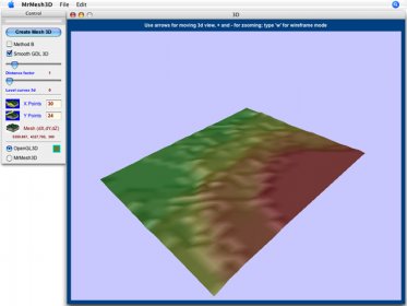
MrMesh3D 2 — Fast, Accurate 3D Terrain Modeling From 2D Plans for Surveying, CAD, and GIS Workflows
MrMesh3D 2 is a powerful solution for converting bidimensional quoted plans into detailed 3D terrain models. Designed for surveyors, architects, and CAD professionals, it streamlines terrain reconstruction with precise tools and flexible export options. This version delivers smoother performance, clearer visualization, and enhanced usability.
Create professional-grade models for land analysis, topographic studies, and digital elevation workflows with intuitive controls ideal for both beginners and experts. The tool fits seamlessly into GIS mapping workflows and terrain visualization pipelines, delivering fast results with high accuracy.
Key Features:
• Open images for manual drawing and tracing of terrain data
• Import quoted terrain points from XYZ text files for rapid 3D reconstruction
• Build auto or manual iso-level curves from DXF polylines (perfect for CAD drafting)
• Manually enter x y z coordinates for custom edits and precision modeling
• Export 2D drawings as DXF ASCII files and create 3D models as XYZ text, DXF 3D ASCII, QuickDraw3D metafiles, or ArchiCAD GDL text
What’s New in This Version:
• 3D model now includes color shading based on Z-coordinates
• Level curves can be displayed directly in the 3D model
• Zoom in/out using + and – keys for easier navigation
• Improved interface with minor design and workflow fixes