GNSS SolutionsGNSS Solutions
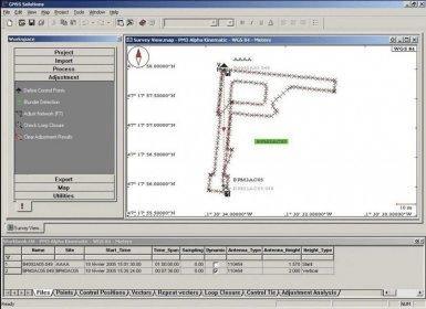
GNSS Solutions (Studio.exe). GNSS Solutions is a comprehensive office program with all the tools required to successfully process GPS...
Manage and process GPS, GLONASS, and SBAS survey data seamlessly with our all-in-one office tool. GNSS Solutions allows you to easily import data, configure background maps, and create detailed land survey projects and mission plans—all from your desktop.
GNSS Solutions is a comprehensive software suite designed to enhance the efficiency of your surveying workflows. With support for static, rapid static, and kinematic survey data, this tool ensures the highest precision and flexibility in managing GNSS data. It integrates seamlessly with configurable background maps, enabling you to visualize land survey projects and plan stake-out missions directly from the office. Streamline your data processing and improve accuracy in every step of your surveying tasks.
 Yate
Yate Jotun Product Resistance List
 VertrigoServ
 FotoMorph
 MyODBC
 Indigo DMA
 Folder Password Protect