Trimble TerramodelTrimble Terramodel
 JetSoft Shield Now
 Trucking Register
 SuperBeam
 Clan Short Reader
 MS PowerPoint Business Plan Pr
 TVMC
TVMC Cole2k Media - Codec Pack
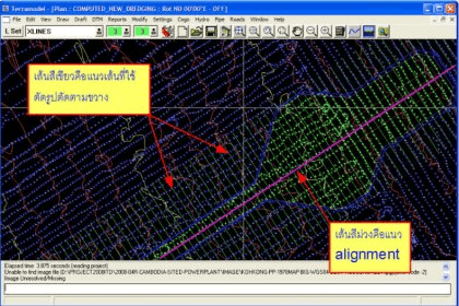
 Trimble Terramodel (Terramodel.exe). The Trimble Terramodel software, is a powerful software package for the Surveyor, Civil Engineer and Contractor...
Trimble Terramodel™ is a comprehensive solution for surveyors, civil engineers, and contractors who need a powerful CAD and design package with seamless support for raw survey data. Ideal for complex workflows, this platform streamlines COGO calculations, roadway design, contour generation, volume analysis, and more—making it one of the best CAD design software options for surveyors.
Import data from Trimble conventional instruments or a Trimble TSCe™ Controller running Trimble Survey Controller™ software, then visualize your entire project in an interactive 3D model. The integrated 3D Visualizer, combined with advanced CAD functions, delivers a smooth survey data processing workflow and a highly efficient quality-control experience. Flexible modules allow Terramodel to be configured to match the exact features you need.
Export road data to the RoadLink module in Trimble Geomatics Office using the TRMBROAD macro, or share DTM data through a 3D faces file. Terramodel TML macros for these features are included on the Trimble Geomatics Office v1.6 CD. Designed as a full survey, CAD, drafting, and surface-modeling solution, Terramodel is built for professionals who require precision and reliable performance.